
Seeking a competitive edge in the mining industry? Discovers how our state of art AI & ML- based technology could capture precise data, empowering you to make informed decisions and minimize operational risk.

Founder & CEO,
Squadrone Infra and Mining Pvt. Ltd.
We Squadrone Infra and Mining Pvt. Ltd., Bangalore, believe in Digital Trans-formation in Mining and Infrastructure by using drone-based technology, to shape the future of mining by integrating AI & ML in Mineral Prospecting, Mine planning, and design, Drilling and Blasting, 3D Reality Modeling, Open pit and Underground mines, and infrastructure to enhance mine safety, efficiency, productivity, and profitability.
We are a team of Mining engineers, Geologists, Aeronautical engineers, Geophysicists, Geotech engineers, GIS experts, etc., with over 30 years of experience in Mining. Our domain expertise in Mining along with deep knowledge of drones, focus on specialized applications of this latest technology in Mineral Prospecting/ Exploration, Open pit mining, Under-ground Mining, Tunneling, etc.
Services Provided by Squadrone :
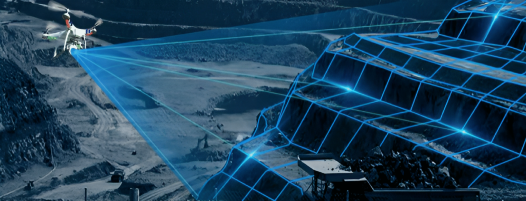
Drone-Based Lidar Application
Squadrone Infra and Mining Pvt. Ltd. is 1st to fly Autonomous drones in under-ground mines in India.
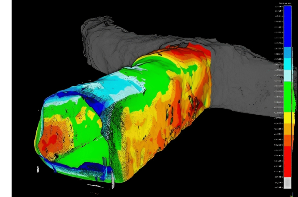
- 3D Reality Modelling of underground mines, using drones equipped with advanced technology, provides precise analysis to find out Undercut – Overcut area, weathered and joint roof, stope area, volume and its condition, Blast design, and other structures without endangering the lives of men in underground mine and tunnels.
- Underground Mining & Tunnelling – Drones enabled with LiDAR and AI generate data on the structure and geotechnical disturbance of tunnels & mines, improving safety to reduce the travelling distance of man & machine and enabling efficient planning of development and support patterns.
Drone-Based Magnetometer
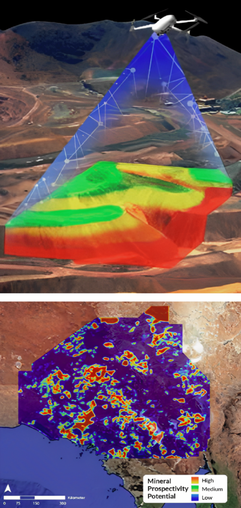
Squadrone Infra & Mining. Pvt. Ltd. – 1st to fly Autonomous drone-based Magneto-meter for Geophysical Survey for Mineral prospecting and Exploration
Mineral prospecting/exploration: Our drone-based magnetometer technology provides a l10 times faster, more accurate, and cost-effective mineral exploration process while promoting sustainable practices in the critical minerals supply chain. With the ability to detect anomalies in the earth’s magnetic field, we can identify mineral deposits up to 600-800m below sea level without disturbing the ecosystem. Specifically establishing mineralized zones & exploration targets. Prospect V/s Reject.
Groundwater exploration: A fast, cost-effective, and environmentally friendly way to explore potential groundwater resources. Equipped with advanced drone-based magne-tometers, identifying potential sites for groundwater exploration. With traditional exploration methods being time-consuming and expensive, our technology allows us to survey large areas of land quickly, saving you both time and money.
Oil and gas exploration: Revolutionize your oil and gas exploration with our cutting-edge drone-based magnetometer technology. Our drones equipped with magnetometers can detect anomalies, and deviations in the strata in the subsurface, providing accurate and efficient data for identifying potential drilling sites.
Drone-Based Ground Penetrating Radar
Mineral exploration/prospecting:
Unleash the power of ground-penetrating radar technology with our drone-based GPR system for mineral exploration. Our advanced drones equipped with GPR can detect and analyse subsurface features, helping identify potential mineral deposits quickly and cost-effectively.
Tailing dams in mines (Strength & Leakage analysis):
Our state-of-the-art drone-based Ground Penetrating Radar (GPR) technology enables comprehensive tailing dam inspections, utilizing high-frequency electromagnetic waves to penetrate and map subsurface layers. Integration of drone-based GPR system with AI & Ml technology detects potential issues such as leaks, voids, and erosion, providing detailed data to prevent dam failures and environmental disasters.
Detection of Underground tunnels, Structures, and pipe leakages:
The advanced capabilities of the Ground Penetrating Radar (GPR) system, can accurately detect underground tunnels, structures, and pipe leakages with high precision and reliability. It can operate in inaccessible areas, providing data that is crucial for efficient tunnelling and pipeline management, using its ability to penetrate deep into the earth’s strata.
Lithological Characterization and Stratigraphic Modelling:
The potential applications of drone-mounted Ground Penetrating Radar (GPR) technology in performing lithological characterization and stratigraphic modelling. It involves collecting subsurface geophysical data through GPR scans, which can then be interpreted to create models that help understand the geological structure and properties of the area of interest.
Digital Transformation in Surface Mines
3D Reality Modelling: This uses drone technology to create precise 3D images of mines, such as sidewalls, dumps, slopes, and blast designs, without endangering surface mining personnel and is reliable & accurate.
Volumetric analysis – stockpile, pit & dump management: UAVs provide safer and faster stockpile, pit, and dump management in mining. They offer 3D views for data analysis and planning, detect changes, and enable a volumetric analysis of area, volume, and height.
Pre-blast: drones can create high-resolution 3D maps of the terrain and geological features, allowing for accurate and detailed planning of drill hole location, depth, and angle. This can improve fragmentation, reduce vibration, and minimize overbreak and underbreak.
Post-blast: drones equipped with sensors and cameras can be used to collect real-time data on blast results, such as fragmentation, muck pile shape and size, and damage to surrounding infrastructure.
Mine Survey/ Topographical Survey: This technology is crucial for monitoring stockpile management, mining opera-tions, haul road optimization, water and sediment flow, mine exploration, blast assessment, tailings dam monitoring, and other critical aspects of surface mining.
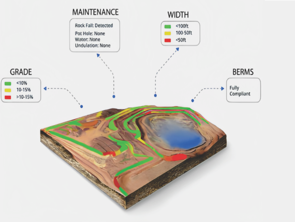
Haul Road Assessment AI: AI technology can detect and assess haul road safety and compliance by automatically identifying parameters such as grade, width, cross-falls, and berm heights.
AI in fragmentation analysis: AI technology can measure 2D and 3D muck pile fragmentation automatically using drones and optimize future shot designs with AI fragmentation prediction models that learn from previous shots.
Subsidence monitoring: UAVs equipped with cameras or LiDAR sensors, integrated with AI/ML algorithms, can monitor subsidence in mining and analyzing data to detect changes in ground level, improving risk detection accuracy and efficiency.
Squadrone Infra and Mining Pvt. Ltd.
Web : www.squadrone.co.in
